

The trail to the summit of Grays peak is actually a National Recreation Trail maintained National Forest Service Trail (which is funny because after about ½ mile of hiking there was no "forest" to be seen.) Grays can now be seen, just above my left shoulder.
 The hiking was quick and steady for the first mile and that's when we first caught sight of the two mountains. Grays is to the left and looks kind of weak, but it is set farther back than Torreys which looks badass and is right above Jess' head.
  We had a wonderfully cool and calm morning through a splendid basin with a rushing creek off to our left and fields of wildflowers everywhere we looked. Pretty much perfect!
After a couple miles of gradual climbing we got basically to the base of Grays Peak. Off to our right was Torreys Peak:  Now it was time for some tougher hiking, which meant now the trail would be rockier and have much steeper grades.
 It also didn't take long to realize just how much of a champ Jess was. She set the pace for most of the hike and while I worried about her burning out it was actually me that was struggling.
  We were both pretty motivated to get to the top however as the last mile or so is just a switchbacked slog up on pretty firm talus. The views were amazing as we continued the ascent.
 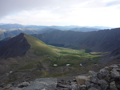 Once we reached about 14000 feet however, the clouds rolled in. We made our final push to the top and soon we were at the highest point on the Continental Divide and Jess' first 14er, Grays Peak, 14270 feet.
 And we couldn't see anything. It was as dense and thick of a fog as I've ever seen and it was cold, I had to add two layers to stay not frozen and we only spent a small amount of time at the top (and made a few friends) as we needed to keep moving to stay warm. It was a bummer as by now I was kind of tired and my favorite part of the summit is the views of all the other mountains I want to climb! Of course I had the appropriate Mountain Dew for the occasion, Mountain Dew Whiteout! Tasty!
  At this point we were also deciding on if we wanted to bother continuing to Torreys or not. Torreys got foggy before Grays did and it seemed to be more weather-prone. And it is a class 2 climb (Grays is a class 1) so it meant for steeper grades and looser more ankle-twisting rocks. Well there are two ways down Grays, the way we came or down the side to the saddle with Torreys and then a traverse trail back down to meet up with the way we came up so the logical choice was to go down to the saddle and make that decision.
  The hike down Grays was fast. The trail is also class 2 so when you can hike down you make very large elevation changes fast.
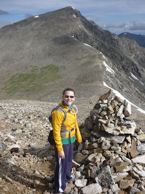 We soon were down to the 13700 foot saddle and the clouds in the saddle weren't as bad, we even got some glimpses west of Breckenridge, the Dillon Reservoir and the Ten-Mile range so that made me happy.
 Breck Ski Area in the far background
 We hung out for a half hour at the saddle while we had a bit of a "picnic" and debated Torreys. Altitude definitely takes a lot out of someone, especially me. We could see people going up Torreys and realized we could probably summit in 45 minutes. I'd kick myself if I didn't go for it. Jess knew that too and basically said we should do it.
The climb up Torreys was probably the best part. We had 3-4 groups all hiking at similar paces and we saw some nice snowfields and rocks. Jess was rocking at this part having to pause every once in a while to wait for me. The summit came before we knew it and we were on top with fun people. 14267 feet of goodness, official summit shot:
  We had cell phone and 3g coverage and we even posted a photo of us on Facebook! But again we couldn't see anything although there was less wind and it was warmer than Grays. I had one Dew left, Mountain Dew Typhoon. It's my favorite of the three but I definitely hope that it wasn't foreshadowing a storm or anything.
  15 minutes later we decided to head back down. We flew down to the saddle (as fast as we fly at least.) I did notice that while we climb faster than most our descending speed is terrible. We both are careful on the loose rock, Jess has bad knees and myself bad ankles, so we take our time while others can practically leap down.
Soon we were at the saddle and then we got to do the snowy traverse. It's the only part that you can appropriately train for in Wisconsin and I dominated it while many others struggled.  Jess decided to do the last 5 feet on her ass too which provided a fun laugh (it was so cold she got up before I could snap a picture!) That was probably the last fun we had. I had one of those overexertion headaches and we were both pretty tired and sloppy. We stopped a few times and had to dismiss layers as it got really warm (it's cloudy on the peaks but sunny and clear under 13500 feet.
  We took our time down to where the trail turns more into dirt that pure rocks. We then had 3 miles of about a 7% downhill grade on dirt/rocks. You'd think that would be the easy part but heck no. I turned the same ankle 3 times which really hindered my speed. We both really needed to go to the bathroom. I turned my other ankle just for fun. We got passed a few times. With a mile to go we got rained on. Just another day in the mountains! We finally made it back to the trailhead which conveniently had toilets. We were both pretty fried, taking this quick snap before jumping in the car and driving rapidly to food.
 Just over 7 hours out on the trail made for a long day, especially with so much above 13700 feet.
Frisco has a complex that has a Qdoba, Noodles and Smashburger all next door to each other. While a burrito is perfect post-climbing fuel I couldn't pass up Smashburger. No one should ever pass up Smashburger; it's awesome!  We drove the final 20 minutes to Breckenridge and were pretty worthless the rest of the day.
Looking back this ended up being one of the hardest hikes I've done. I've done 3 in one day but that was easier. Elbert seemed just as hard because I had some altitude issues that day and I think I underestimated it (and it was my first.) These were my 8th and 9th 14ers out of 54 so I've got 1/6 of them done! I've got another half dozen on my short list as well. This one was special to me as well since they are the first two that Jess did and she rocked. She kept me going when I was tired, dealt with me when my ankles sucked and she kept up her brisk pace all the way to the end. I think she even liked it enough to join me again, which was goal #1. As much as I like the solitude of soloing some of these nothing beats having someone to summit with, and I've been on summits with Wolfgram, my brother Eric, and Kyle and I am so proud to add Jess to that list.

 The beginning of the hike is still on the road however until you get to some sweet mining ruins and the road is basically a double track. Here I missed the turn despite there being a big arrow of rocks and went about a quarter mile before turning around and going the right way (my way would've made it but it appeared to go way out of the way.)
  Awesome. The climb was very tough for me however. I don't think I was acclimated enough but when you start at 10k feet it seems that your body acclimates as you hike. Starting so high was a rough adjustment. I felt like I was making bad time but still passed 20 or so people on the way to the top so that helped the pride even though my legs, heart and lungs all hurt despite not feeling like I was giving much effort. Everyone says how easy Sherman is but Mt Democrat (which I did last summer) seemed far easier to me. I crossed a snow field that most people were avoiding because it seemed like the fastest easiest way up the side.
 The sites were awesome and interrupted the grey talus that littered my view in almost every direction.
  But once you get to the saddle between Sherman and Sheridan the views open up and I remembered why I climb mountains in the first place. Of course looking up to a false summit isn't the best view once you climbed that you could see the final pitch to the top.
 It looks pretty extreme from this vantage point but it was pretty wide and had a very good route to the top:
 That was the slowest part though; it was windy and a little steeper. But there were lots of people ahead of me and I know from my bike racing days if I see someone ahead of me I need to catch and pass them. Finally I summited, around 2 hours after I started. I am the Shermanator! Someone even had a sign with the elevation on it that made it seem even more extreme to my friends back in Wisconsin! :)
 There were 5 or 6 people up there when I got there but before long there were a good 15 people and a yellow lab:
  The views were amazing, Pikes and South Park to the South:
 Elbert, Massive, Leadville and the Sawatch range to the west:
 The DeCaLiBro and Quandary to the north and Gray and Torreys to the northwest.
 Also got probably the best view of South Park. The top was perfectly peaceful with a great mix of people. I decided I had to do at least 3 summits this vacation as I had 3 different flavors of Mountain Dew! Opted for the Dew Distortion on this one however because of me forcing some altitude early into our trip:
  The way down always sucks for me, I always underestimate how much I don't like it. The beginning was fun and I made quick work. That brown dot is the 4 story mining ruin seen from above on my way down:
 Saw 3 more dogs on the way up (one of which was on her 20th different 14er, impressive.) I brought hiking poles with but decided not to use them until I turned my ankle (I have bad ankles and it was only a matter of time.) Of course I turned each one (and never did get the poles out). I turned them after the hard part too, in unlikely spots where I was worried more about speed and less about the rocks. Oh well, they've been turned so many times that I can walk it off most of the time, and these were both very minor. I did get some different views of mining ruins and found the sun to be perfect for a B&W shot of this gem:
 I posted on the forums and ColoradoLawDobe found the pieces of it in the road (clearly run over) and sent me the pieces, time to call Garmin, I was just riding along and my GPS exploded…or maybe they have some discount replacement.